


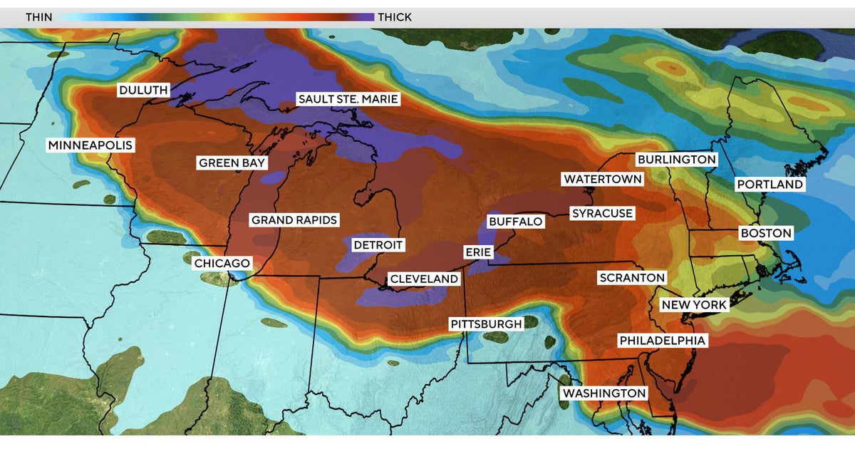
Heavy smoke from wildfires blazing in Canada and Minnesota is engulfing large swaths of the Midwest and Northeast U.S. this week, impacting air quality as millions of people are exposed to hazardous levels of air pollution.
More than 100 wildfires are burning in Canada, and winds are carrying the smoke southeast. Multiple wildfires are raging in northern Minnesota.
High levels of fine particulate matter in the air from smoke can be unhealthy, especially for sensitive groups such as children and people with heart or lung conditions.
Air quality today
Detroit, Minneapolis and Chicago ranked among the top five most polluted major cities in the world on Thursday, as air quality alerts stretched from Minnesota to parts of the Northeast.
Minnesota officials issued an air quality alert through Friday for areas including the Twin Cities metro area, with very heavy smoke expected across the state’s northeastern corner. Air quality levels in northeast Minnesota reached hazardous levels, making it unsafe for everyone.
CBS News 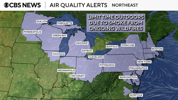
Officials in Michigan and Wisconsin also warned residents about air quality issues that could last for days. The entire state of Michigan was under an air quality alert Thursday, and it could be extended if needed.
An air quality advisory was in effect Thursday for all of New York state, and officials said N95-style masks would be distributed to commuters in New York City.
Gary Hershorn / Getty Images 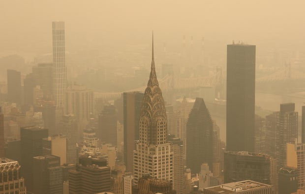
Pennsylvania declared a Code Red air quality alert for Thursday, with smoke from the wildfires creating unhealthy levels of pollution for everyone, the state’s Department of Environmental Protection said.
Air quality alerts have been issued by the Massachusetts Department of Environmental Protection for the entire state.
As a large plume of smoke from the fires seeped into the Boston area, the skies morphed from a milky white to an ominous brown-yellow, CBS News Boston reported.
“It almost felt like you were at a campsite with an active fire going,” West Roxbury resident James Venezia told the station.
The yellowish haze also descended across Vermont, New Hampshire and Maine.
Kristopher Radder/The Brattleboro Reformer via AP 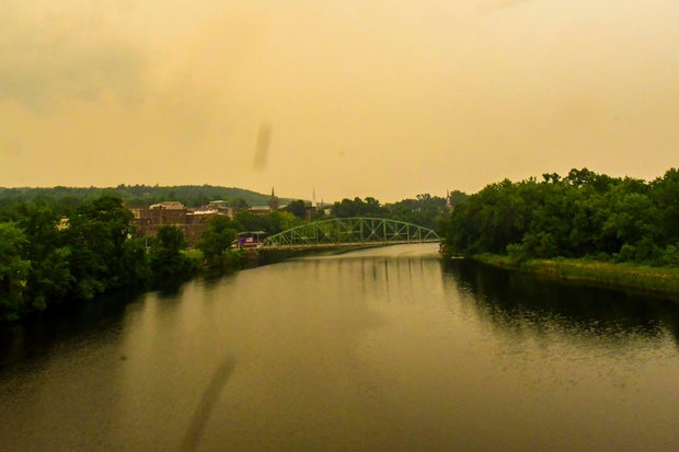
Wildfire smoke maps
The following maps show the wildfire smoke forecast for Thursday and Friday:
CBS News 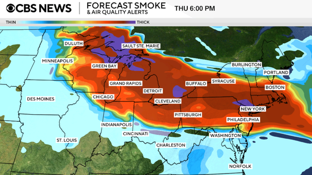
CBS News 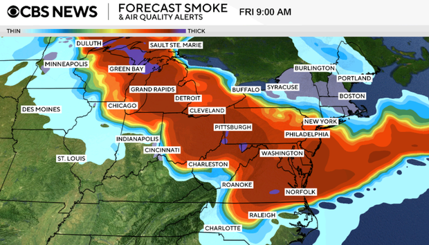
“Not good from a health perspective”
People should stay indoors as much as possible to avoid the smoke, as well as extreme heat, said Tyler Hasenstein, a meteorologist with the National Weather Service in Chanhassen, Minnesota.
“Those two things coinciding with each other is not good from a health perspective,” he said.
Fine particle pollution from wildfire smoke can cause shortness of breath, coughing, dizziness or fatigue and aggravate heart and lung diseases and other chronic health issues. Experts suggest reducing or eliminating outdoor activities, wearing an N95 mask if you have to be outside, and keeping your indoor air cleaner by closing windows and running an air purifier or air conditioner. Long term, exposure to fine particulate matter from wildfire smoke is one of the leading causes of premature death.
“If we keep being exposed to this level of air pollution over time, that increases our risks down the road for developing chronic health conditions,” Dr. Alexander Azan, an assistant professor of population health and medicine at NYU Langone Health, told CBS News.
A study released earlier this year found that chronic exposure to air pollution from wildfires has been linked to tens of thousands of deaths annually in the United States.
“Whether you’re somebody who’s working outdoors [or] you have an errand that you just can’t not do today or tomorrow, the best way to keep yourself safe is buying an N95 or KN95-grade mask,” Azan said.
Canadian wildfires map
Dan Westervelt, associate professor at Columbia University’s Climate School, said severe drought conditions combined with heat in Canada and the U.S. have created “a perfect storm for really dry conditions to provide a lot of fuel for these wildfires to burn.” Research shows warming temperatures from burning coal, oil and gas are making fires more frequent and intense.
This map shows the span of the Canadian blazes, the majority of which are burning out of control.
Mehmet Yaren Bozgun/Anadolu via Getty Images 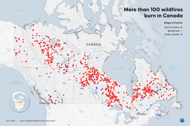
A dramatic video captured the moment a freight train near Armstrong, Ontario, was suddenly surrounded by a wall of burning trees earlier this week. A panicked crew watched everything around them burn as they were unable to move until another train passed.
“This could potentially overtake us here, this has gotten a little scary,” one crew member said in the video.
The Canadian National Railway later suspended rail operations there, but said everyone on board the train got through safely.

